As you know, I’m not one for nicely written activation reports. I also generally neglect to take decent photos but I thought I’d share these as they tell their own story.
I’d planned on going back to Harter fell (ldw-112) during the half term break but the weather looked rubbish all week (the days it was passable I was away, which also helped). Saturday didn’t look too bad so I thought I’d take a punt. Eskdale isn’t too far away from me but as it’s down little lanes it takes about 40 mins to get to the bottom of Hardknott pass.
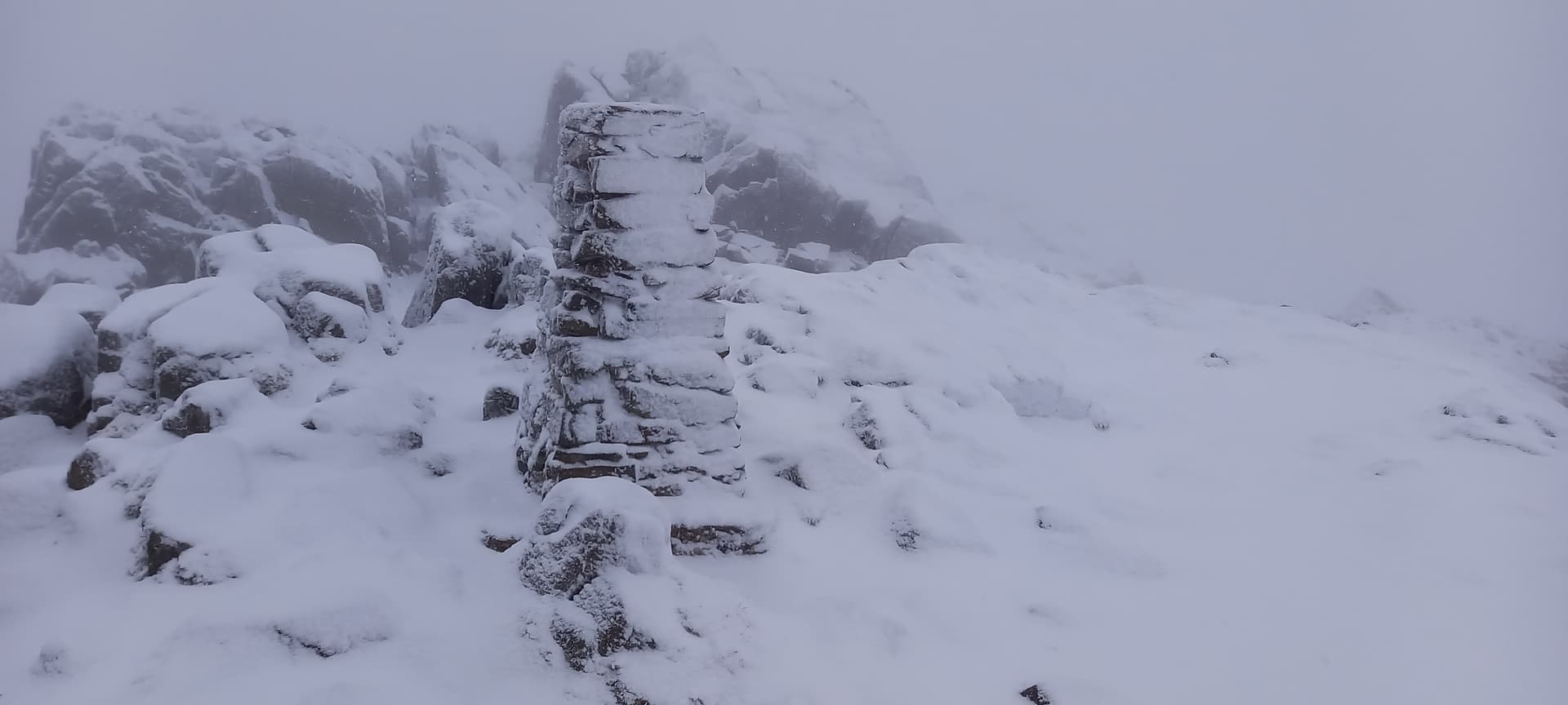
I keep missing part of the path up from there as it gets a bit difficult to follow as you get into the open fell part, so here’s the 2nd attempt to getting it right in a few months (Which I didn’t). Sleet turned to snow and the cloud descended. The result was a white out with shortening visibility by the minute. by the time I left the summit it was around 30m.
I quite like it like this although you I need to be careful on choosing the right route off. Very easy to stray when it’s like this.
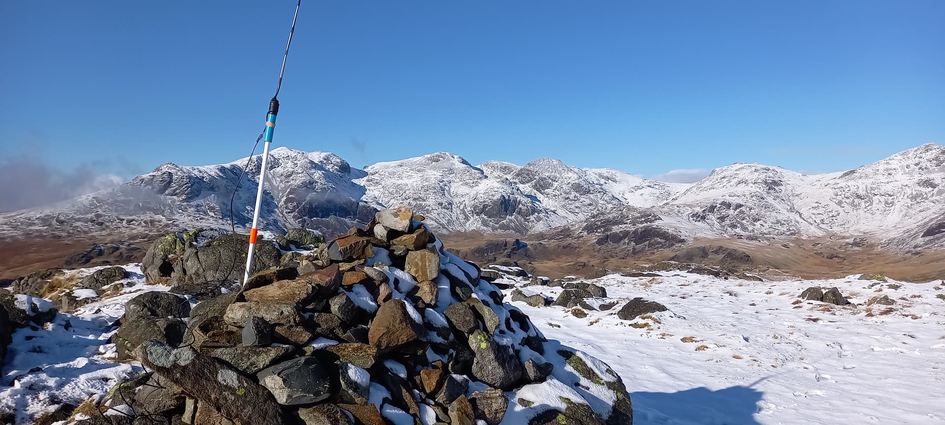
Got down ok and managed to follow the path correctly this time. The snow actually helped. Got back to the car just as the cloud cleared and the temperature hit 9c (a bit weird). I had some lunch and seeing as I was in the area and just about had enough battery in the VX8 I trotted up the pass to the top and went up hard knott (ldw-151) in the sunshine.
hi alex
great report and photo’s to show the conditions and how they can change
with me it goes from good to bad unlike with you’re activation the reverse was the case. you were very strong 59 plus into Cockermouth, it would have been interesting to have listened for you on Hard Knott for some reason i have difficulty with that one, there must be some higher fell in the way from your photo i would say it must be Scafell Pike
i look forward to seeing and hearing about your HF qrp project
73 reg 2e0ldf
There’s quite a bit in the way Reg although you were very strong on Harter. those few extra metres make all the difference then.
I’ve started on the write up on the old blog. I’ll update it when I’ve used it a bit more and more likely make a comparison between it and the MTR which is my favourite
It was a mixed bag of localised weather conditions on Saturday it seems Alex , some nice pictures there too. Spent the day by the lake at Loweswater myself , where it rained in the morning then the wind dropped and the sun came out but it was 2C when we arrived an about 3C at the end of the day . I wondered what it was like where you were as I’d seen your activation posted and took the hand held on the off chance I heard you . I’ve worked a couple of SOTA activators from there one on Green Lowther fell in Scotland surprisingly . I switched on at 12pm but had apparently failed to switch the radio off last time and had a dead battery.
Richard
I’ve only activated Harter Fell twice, both in nasty winter conditions.
I read an article a while back of someone who bothied over night and the photos looked magical. I’m going to wait for a nice warm, summer day to do it next time.
I got similar photos to you from Hard Knott. With a well defined snow line and 270 degree mountains it is a wonderful summit for views on days like that.
Back in mid June I activated Harter Fell then followed a roughly north-south path (to the east of yours) to cross Hard Knott road and activate Hard Knott (LDW-151). My path was also a bit faint in places and I can imagine - looking at your photos - it could be hard to follow either path in the snow.
My nightmare bit came on the return journey (going south) through the Dunnerdale forest plantation to the east of your path back to the car by the River Duddon. The south-bound public footpath was easy enough so were the forestry trails but I ended up on one trail which, although clearly marked on my GPS OS Map app, could not have been used for decades and has mature trees and bushes growing all over it.
I ended up bushwacking through steep ‘unwalkable’ unmanaged trees like a northern jungle. I’ve had this several times before - there’s insufficient detail on the map to help and you just have to follow your instinct as to which way to go. I’ll rather be ‘lost’ [in a local sense] out in the open rather than in dense woodland where your horizon is 5 or 10m.
I know what you mean Andy. I’ve done that loads of times, even as recently as the other week in the Whinlatter forest. I must have cycled through it 50 times and still managed to think I was in one place when I was actually on a different path. Fortunately there it’s easy to nip across some easy terrain. My first ever activation was Harter Fell and I studied the map and think I did exactly what you did. The lakeland maps can be misleading especially when there are sheep trails criss crossing footpaths.
When I go out with a friend of mine he always takes the micky out of me because if the ground has multiple paths I always go the wrong way just enough to make it look like I’m zig zagging the actual path . I also tell him that whatever the time it will take to the next way point is 20 minutes. He’s stopped believing me now:grin:
Seriously though, my GPS has really helped in situations like last week when visibility is so bad. I find a combination of slow progress and lots of checking gives me more confidence even if I do zig zag a bit
Picking up Andy’s point, getting somewhat lost in heavily wooded areas is extremely aggravating, not to say hazardous. OS mapping of public paths and bridleways can bear little relationship to the reality of actual physical routes sometimes. I find most Wainwright routes, even in old books, tend to be pretty reliable, with something to follow on the ground (except some cross-country … ones). While OS mapping might not be perfect, the OS Maps app is pretty useful to show you exactly where you are lost! Various apps will give you a grid reference for your paper map of course - I was assisted in a High Street whiteout by the (free) OS Locate app once: I downloaded it on the spot! 73, Phil
Yes, it’s a unique situation to know your position on the Earth’s surface down to less than 25m thanks to GPS but be navigationally blinded in the short range by dense foliage. Trying to walk by the shortest route to the nearest track or road marked on the map could be hazardous due to the terrain.
I’ve very happy with the OS Maps app on the whole. It’s unrealistic to expect these remote plantations to be re-surveyed that often but that section of the forestry ‘road’ should be deleted from the database.
One situation that checking the GPS has helped me many times is where I’m ascending a rocky mountain and there’s a choice of paths and it’s not clear which one to follow, so I choose one but checking my position after a minute or two, it’s clear now I should have taken the other path, and have to back track.
I’ve also bought the Harvey ultramaps for the lakes as my old os paper maps was frankly knackered. Really happy with the Harvey maps for planning and they are pocket sized which is handy
 . I also tell him that whatever the time it will take to the next way point is 20 minutes. He’s stopped believing me now:grin: