I’m doing a limited release of the QSO Mapping Tool I’ve been working on. At the moment it is hosted on a server at home, so I can’t guarantee availability but if you want to try it please let me know how you get on. This is the tool I’ve used to generate the lovely QSO contact maps on Google Earth. The stations and contact links are both selectable for more information.
It takes an ADI file as input. It queries QRZ.COM for station details and knows about WOTA, SOTA, HEMA and POTA references.
Please give it a try and let me know how you get on.
It’s available here: ADIF Processor.
If successful you’ll get three files out:
A new ADI file with location data set, where possible, for all contacts.
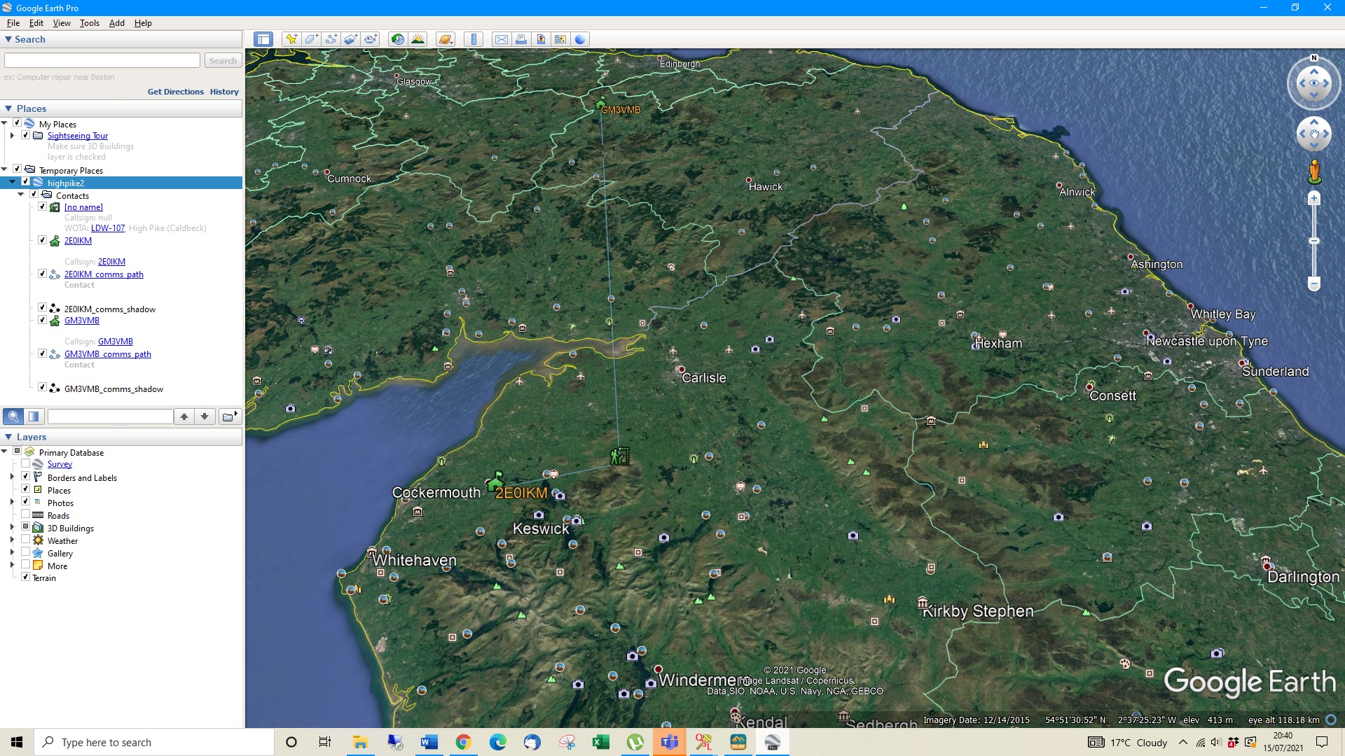
A KML file that can be opened as a ‘project’ in Google Earth.
A markdown file which can be pasted into WOTA discourse and SOTA reflector to generate a table of contacts.
If it falls over please let me know the filename you tried to upload, and I can check the server log.
I have been playing around with the ADIF PROCESSOR file and successfull did my High Pike activation. After saying that i only put 2 callsigns in as the other 2 are not on QRZ.COM.
It took me a few goes as i had not put the coordinates in correctly. In fact 1 kml file i generated had the summit in the North Sea. However i think i have got the hang of it.
I will have a go with some of my other activations in due course.
Mark, thanks for creating the QSO mapping tool and making it available to the rest of us.
I used it to enhance my recent 3-WOTAs activation report with Google Earth ‘contact maps’ for each of the three activations.
It’s straight-forward to use. For anyone thinking of having a go, here’s what I did:-
transfer paper log into a logging program (Fast Log Entry, in my case) and export an ADIF file. Some chaser locations are not specified and you might have to include the chaser’s maidenhead locator in your original log file.
Import the ADIF file to the mapping tool. You probably need to specific your lat,long coordinates in the tool’s main menu.
Download the KML file generated and open it with Google Earth to see the paths between you and your contacts.
I used Window 10’s Snip & Sketch utility to create a JPEG file of the mapping, then import the JPEG into my activation report.
Note if you enter an activity reference (in our case a WOTA references such as LDO-101) then you don’t need to enter a location - the location will be looked up from the reference.
I don’t think that is obvious from the control form layout as it is now.
For some activities, notably Parks on the Air, there isn’t a location as some ‘parks’ are actually trails.
You might also do like I do and record a 10 character Maidenhead locator when on a summit via HamGPS and use that as a more accurate reference to you location. If you enter a 8 or 10 character location in this case together with an activity reference the more accurate location will be used.
I’ve had a quick play with it using an adif file created by SwissLog but it generated errors messages - none of which I really understood!
However, having used Logger32 today on a club field day on Dartmoor I’m going to give that another go and will try one of its adif file exports and see how I get on.